Assets, directories & data
Move from a live map card to a durable asset profile, peer comparison, directory, leaderboard, and the source dataset underneath it.
Browse assets- Status
- Live
- Access
- 2 detail pages without an account · Free account after
- Reading time
- 13 minutes
- Reviewed
- Oct 2, 2026
- Maintained by
- Grid intelligence
Ask the Grid treats a plant, storage site, price location, zone, line, substation, data center, and organization as different records with different evidence. A live card answers what is happening at the current map selection; a public profile preserves identity, geography, ownership, operating evidence, nearby infrastructure, and the source notes needed to understand a longer-lived asset.
Directories and collection pages provide the market-wide path. Search the fleet, narrow by market or asset class, compare compatible fields, then open the data catalog when the decision depends on coverage, cadence, schema, or the distinction between a reported field and an Ask the Grid join or estimate.
The info card
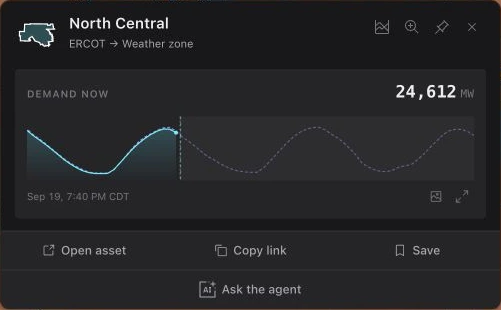
Everything about one asset
Select an asset on a market map to open a card with its name, type, metadata, and—where available—a photo. A river gauge card shows its latest available stage or flow with the observation timestamp, flood thresholds, and nearby hydro plants. At a selected historical time, it shows the last observation at or before that time; future readings are labeled as forecasts. A shared gauge link restores that gauge when opened or reloaded. Select a plant in the nearby list to open its card; select a river reading on the plant card to return to the gauge. The interactive map, info cards, and multi-asset selection open with a free account; a shared map link shows its selected card read-only to anyone who opens it.
Live value & sparkline
Zones show live demand, nodes show price (LMP), and plants show generation — each with a smooth live counter and a sparkline over the scrubbed window. Zones add a forecast overlay.
Hover the sparkline for the value at each timestamp; the card follows the map's time scrubber.
Expand the chart
Select expand on a card's chart and the card grows over the map into the full chart: the values at the cursor, a time control that reaches back through the history, and PNG, CSV, a link to the view, API, and MCP. On a wide screen the agent's sidebar stays open beside it, and Ask opens the conversation there with the chart attached. The chart's title opens the asset's own page, which carries the same chart with more around it. On a phone the chart opens full screen instead.
Close or press Esc and the chart shrinks back into its card.
What an ERCOT plant did
An ERCOT plant's card reads its output from ERCOT's 60-Day SCED Disclosure: the plant's last disclosed day in five-minute steps, its peak, and the energy it delivered, then its output by month from the same disclosure. A battery's day draws charging below the line and discharging above it, with the state of charge it moved through, the average real-time price it discharged and charged at on its own settlement point, the spread between the two, and the reserves it held. ERCOT publishes the disclosure about 60 days after each operating day, so every reading carries the day it runs through.
Hover a month's bar for its energy and how many days of it ERCOT has disclosed.
Reported output from EIA-923
Where ERCOT has disclosed nothing for a plant, including every plant in other markets, the card shows the plant's own EIA-923 filing: monthly net generation and capacity factor, or for a battery the energy it discharged. Most plants file once a year, so a filing that is not current leads with the twelve months it covers and names that cadence.
Drill-down detail
Expand the detail section inside a card for the deeper read.
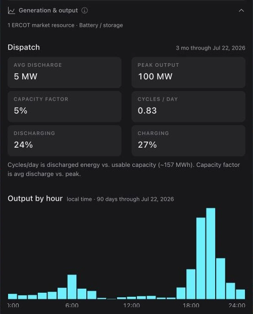
Battery dispatch — storage plants
For ERCOT battery systems, Generation & output shows the ERCOT market resources behind the site, average discharge, peak output, capacity factor, cycles per day, charging and discharging share, a 90-day hourly output shape, and the latest two weeks of disclosed output. Output comes from ERCOT's 60-Day SCED Disclosure, so it trails real time by about 60 days.
Generation & output — other plants
For other ERCOT plants matched to market resources, the same accordion shows average and peak output, capacity factor, uptime, curtailment where reported, a 90-day hourly shape, and recent disclosed output. Plant cards in every market list operator, technology, county, and nameplate capacity where the registry supplies them.
Price detail — nodes
Open a price node's Price detail for average, median, and 99th-percentile price, the largest spike, spikes above $1,000/MWh, negative-price share, where the node ranks among other nodes, average price by hour over the trailing 90 days, and 14 days of hourly price history.
Interactive cards live in the workspace
A free workspace opens live map selection, current info cards, historical price, generation, battery dispatch, and deeper operating panels. A read-only shared map preserves the selected card for anyone opening the link.
Sample 2 asset or forecast details
Asset pages add ownership, evidence, related facilities, operating history, and durable source notes. An anonymous browser can open 2 unique asset or forecast detail pages across the shared public sample. Reloading or returning to one of those pages does not spend another view; a free account continues without that limit.
Asset pages and directories
Move beyond the current map selection when you need a durable profile, a peer set, or a market-wide inventory.
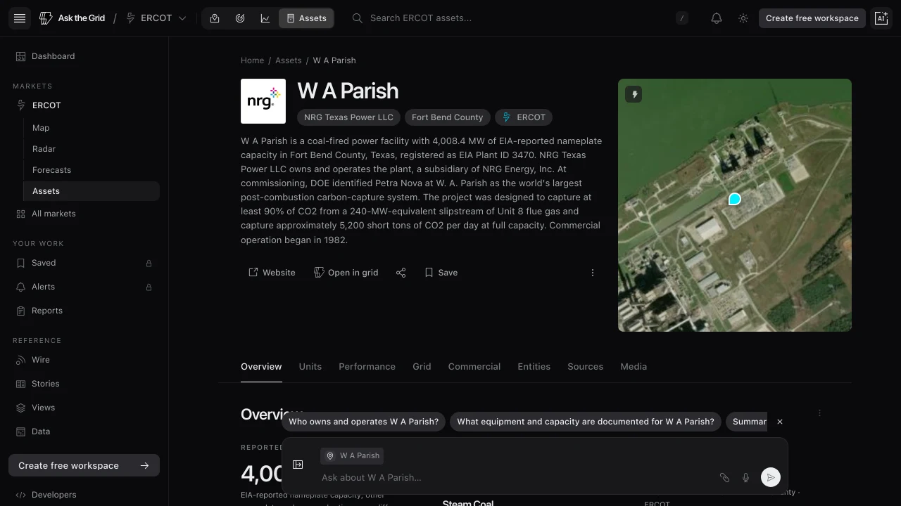
Browse the asset directory
Open a market's Assets page to search and filter its source-backed inventory. Directory rows show comparable identity, location, technology, operator, and capacity fields and link to the corresponding profile.
- 1Open Assets for the active market.
- 2Search by plant name, operator, county, technology, or fuel.
- 3Open a result to review its evidence-backed profile.
Read a full profile
Plant, price-node, zone, line, and other supported profiles keep identity, geography, ownership, market context, operating evidence, nearby assets, and related facilities together, organized into sections such as Overview, Performance, Grid, Entities, and Sources where the record has that evidence. Plant profiles add national and state peer rankings. Source notes distinguish reported facts from Ask the Grid joins or estimates. A data center mapped with a Census street-address geocode labels its map point approximate beside the summary and links to the geocoder record in Sources; that point is not a surveyed building footprint.
Compare compatible assets
On a market map, select two to four power plants to compare their registry, engineering, and operating metrics on a consistent EIA basis. Select two to four compatible price locations—settlement points, hubs, or published price zones—to compare their identity and real-time price history on one shared market clock. Comparisons stay inside one operator market and preserve selection order, with price locations labeled A through D; mixed physical and market-location selections stay on the map instead of implying a direct relationship.
Compare without the map
Use Compare assets side by side on the Assets page, or open askthegrid.com/assets/compare, to type what you want to compare instead of finding it on the map. Choose Power plants, Price locations, or Congestion path, then the market, and search each entry by name or settlement point; the list offers only what that comparison accepts. Add up to four plants or locations; a congestion path takes a source and a sink, with Swap to reverse them. The result is the same page the map's selection opens.
- 1Open Assets and scroll to Compare assets side by side, or go to askthegrid.com/assets/compare.
- 2Choose Power plants, Price locations, or Congestion path, then the market.
- 3Type each entry and pick it from the list.
- 4Select Compare, or Read the path.
Read volatility side by side
Below the price statistics, Volatility names the more volatile location and by how much, then compares each column's volatility tier, price standard deviation and its percentile, 99th-percentile price, intervals above $100, $250, and $1,000 with their share of the window, and hours above $250 and $500. The tier and percentile rank a location against every priced location in its own market over the same trailing window, because ordinary volatility differs widely between markets. The highest value in each row is bold; a tie marks none.
Use counties, leaderboards, and operator views
County hubs roll up installed capacity and local facilities. Leaderboards rank the largest plants of each major technology by a clearly labeled measure, while organization pages group the operating plants EIA-860 reports under a named company. These are discovery views, not claims about real-time availability or economic control.
The data catalog
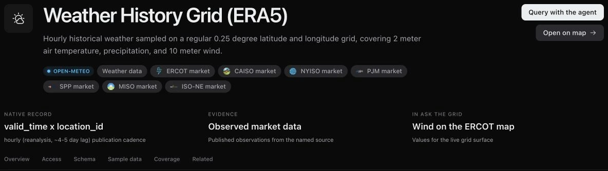
Every dataset behind the map
The catalog lists the public datasets Ask the Grid runs on — ISO market feeds, EIA generators, HIFLD transmission, weather, and more — grouped by category, each with its source, query contract, schema, a live sample, and a coverage calendar.
- 1Open Data from the left navigation.
- 2Search, or filter by category, market, or source.
- 3Pick a dataset to see its columns, a 25-row sample, and how far back it goes.
Current and forecast weather
Weather Forecast Grid (Current + Ahead) supplies hourly Open-Meteo forecasts on a 0.25-degree grid about two days ahead: temperature, humidity, cloud cover, solar radiation, precipitation, and wind at 10, 80, 120, and 180 meters. Use it for current conditions and the hours ahead.
- 1Open Data from the left navigation.
- 2Choose Weather Forecast Grid (Current + Ahead).
- 3Review its coverage, cadence, schema, and sample rows.
Use Weather History Grid (ERA5) for historical analysis. ERA5 is a delayed reanalysis that trails real time by several days and should not be treated as the current hour.
Plan a data subscription for your own tools
Open /data-services to explore catalog examples and request a data evaluation. Describe the markets, datasets, history and analytical environment you need. The team confirms the coverage, delivery approach and permitted use with you; a catalog listing describes the public dataset and does not by itself define a commercial subscription.
- 1Inspect the source, cadence, schema and coverage of the datasets relevant to your workflow.
- 2Open Data services from the Developers menu and select Request a data evaluation.
- 3Include your market, analytical task, historical range, data stack and intended use in the request.
Did this guide get you unstuck?
One click is enough. No message or account required.